One geospatial console to plan, command, and monitor uncrewed missions across air, land, sea, and space.
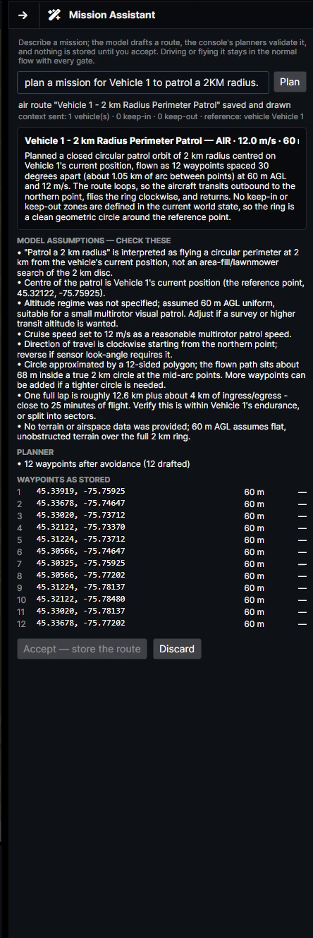
VANTAGE includes a Mission Assistant, a planner you talk to. Describe what you need in plain language and it drafts a complete route in seconds, waypoints, altitudes, speeds, and timing, drawn on the live map.
One sentence is enough. This exact prompt produced the Mission Assistant plan shown in the panel.
The draft lists every waypoint and every assumption the model made, so the operator can check its work.
Nothing is stored and nothing flies until the operator accepts the route.
Upload to the vehicle and watch the mission unfold live, on the same map it was planned on.
The drafted ring, accepted and flying. One prompt became twelve waypoints and a live patrol.
VANTAGE doesn’t lock you into one airframe or one vendor. It commands vehicles over the open standards the industry already speaks.
MAVLink is the protocol spoken by most small drone autopilots. VANTAGE commands it natively, arm, task, retask, and watch live telemetry, straight from the map.
STANAG 4586 is NATO’s standard for uncrewed aircraft control, one ground station, many aircraft. VANTAGE implements it to command tactical UAS from launch through recovery.
SAE JAUS is the interoperability standard for uncrewed ground vehicles. VANTAGE tasks JAUS vehicles from the same console as the aircraft above them, one picture, every domain.
Plan, launch, patrol, and land. One continuous mission, exactly as the operator flew it.
Routes, corridors, and orbits drawn against live terrain, imagery, and airspace, from globe to street level.
Elevation-aware altitudes and clearance warnings baked into every leg of the route.
Geofenced volumes the planner respects and the vehicle enforces.
Dissimilar vehicles, one operating picture, per-vehicle tasking and telemetry.
Fly the mission against a simulated vehicle before a real one leaves the ground.
Request a briefing and we’ll plan and fly a mission live, prompt to touchdown.
Request a briefing →